
NE NEWS SERVICE
CHENNAI/PUDUCHERRY/AMARAVATI, NOV 28
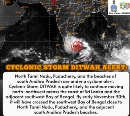
Cyclone Ditwah, intensifying over the southwest Bay of Bengal, is steadily heading toward the coasts of Tamil Nadu, Andhra Pradesh, and Puducherry, prompting multi-agency preparedness and a wave of safety advisories for coastal residents. The Indian Meteorological Department (IMD) has cautioned that the system is likely to move closer to Chennai by Sunday, bringing heavy rainfall, strong winds, and potential disruptions along the eastern coastline.
According to the latest IMD bulletin issued at 2:30 am on Friday, the cyclonic storm moved north–northwestwards at around 10 kmph over coastal Sri Lanka and adjoining Bay waters. It is currently centred near latitude 8.1°N and longitude 81.2°E, located approximately:
The #Cyclonic Storm #Ditwah [Pronunciation: #Ditwah] over coastal #Sri_Lanka and adjoining southwest Bay of Bengal moved slowly northwards with the speed of 3 kmph during past 6 hours and lay centered at 1430 hrs IST of today, the 28th November 2025 over the same region, near… pic.twitter.com/mKApp4kvWa
— India Meteorological Department (@Indiametdept) November 28, 2025
- 50 km south of Trincomalee (Sri Lanka)
- 70 km northwest of Batticaloa (Sri Lanka)
- 220 km north of Hambantota (Sri Lanka)
- 460 km southeast of Puducherry (India)
- 560 km southeast of Chennai (India)
The storm is expected to continue tracking along the Sri Lankan coast before curving toward the southwest Bay of Bengal near north Tamil Nadu, intensifying rainfall activity across several districts until December 1.
STATEWIDE RAIN & WIND ALERTS
The IMD has forecast:
- Heavy to very heavy rainfall in Nagapattinam, Thanjavur, Thiruvarur and Pudukkottai.
- Heavy to very heavy rain in Ramanathapuram, Sivaganga, Tiruchirappalli, Ariyalur, Mayiladuthurai, and Karaikal.
- Heavy showers likely in Thoothukudi, Virudhunagar, Madurai, Perambalur, Cuddalore, and Puducherry.
- Scattered heavy rainfall expected in Pudukkottai, Trichy, Salem, Krishnagiri, Dharmapuri, Tirupattur, Karur, and Namakkal.
Strong surface winds reaching 40–50 kmph, occasionally gusting higher, are expected along coastal Tamil Nadu, Puducherry, and Karaikal.
NDRF, SDRF & DEFENCE FORCES ON STANDBY
With the threat of heavy rain, storm surge, and disruptions, NDRF teams have been pre-positioned in vulnerable zones of Tamil Nadu, Andhra Pradesh, and Puducherry. State Disaster Response Forces (SDRF) have been deployed for:
- Rapid evacuation
- Fallen tree clearance
- Flood rescue support
- Powerline and structural safety monitoring
The Indian Navy and Coast Guard have placed ships, aircraft, and rescue teams on alert to assist coastal districts, monitor sea conditions, and ensure maritime safety.
FISHERMEN WARNED: “DO NOT VENTURE INTO SEA”
The IMD, Coast Guard, and Fisheries Departments have issued strict warnings:
- No fishing boats should enter the Bay of Bengal until further notice.
- All boats currently at sea have been advised to return to the nearest harbour immediately.
- Rough to very rough sea conditions with high waves and strong currents are expected along the TN–AP coast.
Harbours in Nagapattinam, Thoothukudi, Karaikal, Chennai, and Vishakhapatnam have hoisted danger signals.
GOVERNMENT SAFETY ADVISORIES
#CycloneDitwah பாதிப்புகளில் இருந்து மக்களைக் காக்க 14 மாவட்ட ஆட்சியர்களுடன் முன்னெச்சரிக்கை நடவடிக்கைகள் குறித்து ஆலோசனை மேற்கொண்டு அறிவுறுத்தல்களை வழங்கியிருக்கிறேன்.
16 #SDRF படைகளும் 12 #NDRF படைகளும் கடுமையான மழைப்பொழிவு ஏற்படக்கூடிய மாவட்டங்களுக்கு அனுப்பி… pic.twitter.com/rIyhxAbehj
— M.K.Stalin – தமிழ்நாட்டை தலைகுனிய விடமாட்டேன் (@mkstalin) November 28, 2025
State administrations of Tamil Nadu, Andhra Pradesh, and Puducherry have issued public guidelines:
- Avoid unnecessary travel along coastal roads.
- Stay away from beaches, sea walls, and low-lying flood-prone zones.
- Keep emergency kits ready (water, torch, medicines, batteries).
- Charge mobile phones and follow official updates.
- Parents are advised to ensure children stay indoors during intense rain/wind periods.
Control rooms have been activated in all coastal districts, with round-the-clock monitoring of reservoirs, river inflow, and urban flooding hotspots.
As Cyclone Ditwah inches closer to the east coast, authorities urge citizens to remain alert, follow official advisories, and avoid panic. Continuous updates will be issued as the system evolves over the next 48 hours. Stay safe and stay informed.