
NE ENVIRONMENT BUREAU
CHENNAI, DEC 3
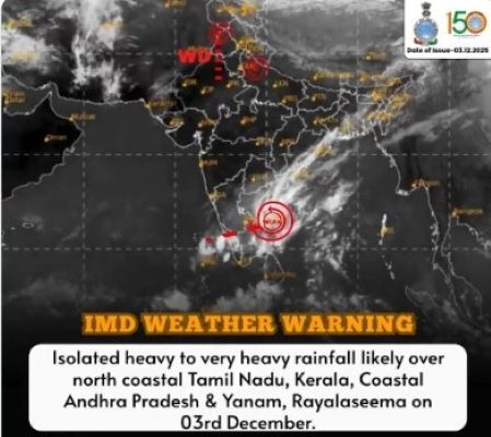
As the remnants of Cyclone Ditwah weaken into a well-marked low-pressure area, its moisture-laden bands continue to deliver heavy rainfall across northern Tamil Nadu and adjoining South-Coastal Andhra Pradesh — a stark reminder that even diminished weather systems can trigger intense monsoon fury.
— IMD-Tamilnadu Weather (@ChennaiRmc) December 3, 2025
The India Meteorological Department (IMD) has forecast heavy to very heavy rainfall, especially in the western belt of Tamil Nadu — including districts like Nilgiris, Erode and Coimbatore — while also warning of possible isolated heavy downpours elsewhere.
Intense thunderstorm activity over Tiruvallur district and adjoining North Chennai continues. Pl follow the NDMA guidelines during lightning and stay safe.https://t.co/RhrEGGhuPY pic.twitter.com/O5XGwYO9z3
— IMD-Tamilnadu Weather (@ChennaiRmc) December 3, 2025
- IMD warns of heavy to very heavy rains over northern & western Tamil Nadu and coastal Andhra
- Chennai and suburbs under red-orange alert; waterlogging disrupts daily life and forces school closures
- Slow-moving low-pressure system, not a cyclone, now fuels sustained rainfall across the region
- Alert issued for thunderstorms and lightning in Puducherry, Karaikal and rain-prone districts
- Authorities urge residents to stay safe, avoid travel and heed weather advisories during monsoon spell
In the capital and its neighbouring districts — including Chennai, Tiruvallur, Kancheepuram and Chengalpattu — unrelenting rainfall has led to widespread waterlogging, traffic snarls, and severe disruption of everyday life.
Authorities have responded by declaring holidays across schools and colleges in the most affected zones and issuing advisories urging residents to avoid non-essential travel.
With the northeast monsoon still active and the low-pressure area lingering near the coast, the IMD has urged all citizens, particularly those in flood-prone and low-lying zones, to stay alert and follow local advisories until further notice.