
- Ranjit Sagar reservoir and human interventions reshape the downstream floodplain
- Satellite imagery spanning nearly three decades reveals a dramatic contraction of surface water
- Median river discharge fell from 296 to 221 cubic metres per second in the periods compared
- Shrinking active channels and expanding vegetation signal changes in floodplain dynamics
- Researchers call for integrated reservoir, sediment and sand-mining management to protect river health
NE ENVIRONMENT BUREAU
GANDHINAGAR, OCT 16
What happens when a river continues to exist on the map, but the water that sustains its floodplain becomes dramatically less visible? A study involving researchers from the Indian Institute of Technology Gandhinagar (IITGN) offers a sobering answer: the Ravi River’s estimated surface-water area across the examined downstream floodplain shrank fivefold after the Ranjit Sagar reservoir began operating, while vegetation and human activity reshaped parts of the river landscape.
Published in Next Sustainability on August 28, 2026, the study, titled Unraveling the impacts of reservoir regulation and sand mining on the Ravi River, India, combines long-term discharge estimates with satellite observations to investigate changes in river flow, surface water, vegetation, channel pathways and human encroachment.
The findings highlight how reservoir regulation, sediment disruption, sand extraction and other human interventions can interact to alter a river’s natural processes. The researchers argue that sustainable water management must look beyond water storage and delivery to consider the health of river channels and their connections with surrounding floodplains.
A reservoir can store water—but what happens downstream?
Reservoirs serve essential purposes, including irrigation, hydropower generation and the regulation of water supplies. Yet changing a river’s natural flow can have consequences beyond the dam itself.
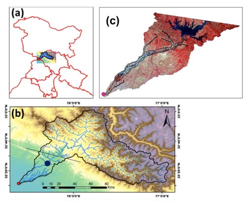
The Ranjit Sagar Dam, also known as the Thein Dam, was constructed on the Ravi River near the border of Punjab and Jammu and Kashmir. Since the reservoir began operating in 2001, the downstream river system has experienced changes that the IITGN-associated research examined through discharge records and satellite imagery.
A river’s health depends on more than the quantity of water passing through its main channel. Seasonal flows help move sediment, maintain channel diversity, replenish floodplains and sustain habitats. When the timing and magnitude of flows change, the river’s ability to transport sediment and interact with its floodplain may change as well.
Dr Indra Mani Tripathi, the study’s first author, a postdoctoral research associate and an IITGN Earth Sciences PhD alumnus, explained the particular vulnerability of dryland rivers.
“In dryland regions, where water availability is already limited, communities and ecosystems may depend on seasonal flows. Even relatively small changes in water can have impacts on biodiversity, water availability, and ecosystem functioning in such systems.”
The numbers behind the changing river
The researchers examined river-discharge data covering 1980–2019 and compared conditions before and after the reservoir began operating. Their analysis focused on April and May, the pre-monsoon months, to examine seasonal flow conditions.
The study’s reported median discharge figures fell from 296 cubic metres per second during 1980–2000 to 221 cubic metres per second during 2001–2019.
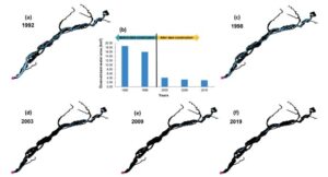
The more striking finding concerned the extent of surface water across the examined floodplain. The estimated mean surface-water area declined from 17.35 square kilometres to 3.46 square kilometres—a fivefold contraction.
Satellite images from 1992 and 1998 showed a more prominent network of water features across the floodplain. In imagery from 2003, 2009 and 2019, these features became much less apparent.
These changes suggest a substantial contraction of the active surface-water landscape in the study area. They should not, however, be interpreted as proof that the Ravi’s entire water supply fell by the same factor or that agricultural losses were directly measured.
Professor Vikrant Jain, Head of the Department of Earth Sciences at IITGN, highlighted the implications of sustained changes in river flow.
“A sustained change in flow impacts the river’s ability to transport sediment, which further leads to changes in river morphology and floodplain processes. Over time, such aspects can influence the connection between the river and its floodplain.”
When water retreats, vegetation advances
The study also identified an increase in vegetation in parts of the floodplain where the active water area had contracted.
That change may appear positive at first glance. Yet vegetation growth in a floodplain can also signal that periodic flows and sediment movements have become less frequent, allowing plants to establish themselves in areas previously influenced by moving water.
Professor Pranab Kumar Mohapatra of IITGN’s Department of Civil Engineering explained: “In a floodplain, periodic movement of water and sediment helps keep some areas dynamic. When these processes become less frequent, vegetation can establish more easily, potentially making some parts of the floodplain more stable and less connected to the active channel.”
The process is comparable to a footpath through a field: when people stop using it, grass and shrubs gradually grow over it, making the path harder to recognise and use.
In a river floodplain, the consequences may be more complex. Changes in vegetation, channel pathways and sediment movement can affect the landscape’s connectivity with the main river and influence how the ecosystem functions.
Sand mining and human encroachment add to the pressure
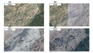
The researchers also examined sand mining and other human activities using high-resolution imagery, including Google Earth. They identified features such as artificial pits and locations where river pathways had changed.
The impacts were not uniform across the floodplain. Particular areas showed evidence of human encroachment, ponding and other geomorphological changes, while sand extraction intensified channel and floodplain modifications in specific zones.
The findings underline the need to consider multiple pressures together rather than attribute every observed change to the reservoir alone.
Dr Ankit Modi, a former research associate at IITGN and an assistant professor in the Civil Engineering Department at Gujarat Technological University, said: “Our study indicates that effective river management needs to consider several factors together. Changes in flow, sediment movement, land use, and sand extraction can build upon one another over time. Understanding these interactions gives us an opportunity to identify where interventions can help maintain a healthy balance between human use and river processes.”
The distinction matters for policymaking. Reservoir operations, sand extraction, land-use change and other interventions may influence different parts of a river system in different ways. Effective management therefore requires evidence-based assessment of their combined effects.
From the Ravi to rivers around the world
Dr Shanti Shwarup Mahto, an IITGN Earth Sciences PhD alumnus and an assistant professor at the Central University of Jharkhand, placed the findings in a wider international context.
“The Ravi is part of a much larger global story. Around the world, rivers are being modified by dams, sediment extraction, land-use change, and climate variability. Our study places the Ravi alongside examples from the Colorado, Mekong, Murray, and Yangtze, among others. The more information we have about how such factors interact, the better equipped we are to manage water infrastructure while preserving the river processes that support healthy floodplains and ecosystems.”
The study’s implications extend beyond a single river. Across the world, dams and other water infrastructure help meet human needs, but managing their environmental effects requires an understanding of how water, sediment, vegetation and human activity interact.
India’s National Water Mission emphasises water conservation, reduced wastage and equitable distribution through integrated water-resource management. The study also aligns with the broader objectives of United Nations Sustainable Development Goal 6, which calls for sustainable water management and the protection and restoration of water-related ecosystems.
The researchers point to the importance of maintaining river connectivity and managing sediment, including through approaches addressed in Central Water Commission guidelines on longitudinal connectivity through dams.
The research team also included Dr Aamer Majid Bhat, a postdoctoral research associate, and Bhanu Parmar, a junior research fellow, from IITGN’s Department of Civil Engineering. The researchers acknowledged financial assistance from the Ministries of Education, Science and Technology, and Earth Sciences, Government of India.
The warning emerging from the Ravi is not that reservoirs have no place in water management. It is that their benefits must be weighed alongside the ecological processes that sustain rivers downstream.
A river’s health cannot be measured by stored water alone. The real test is whether its flow, sediment and floodplain continue to function as a living system.